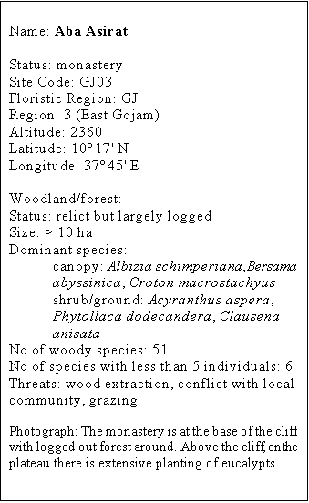
Aba Asirat
Since the fall of the Derg regime the large Aba Asirat
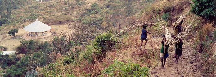
monastery has suffered from extensive deforestation. The site has afflicted by
a major conflict of interest over the control of the natural tree resources
between the monastery (preservation) and the local community (exploitation).
Aba Asirat monastery
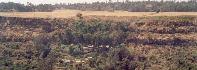
is situated on the eastern slopes of a canyon right at the edge of the main
highland plateau. This small canyon runs East and feeds directly into the Blue
Nile. The upper part of the monastery is delimited by a ca 50 m high cliff
whilst the remaining consists of a mainly steep slope down to the river’s edge.
The original monastery
forest covered the whole left side of the valley, however today no high forest
remains. Over the past decade all trees have been cut down but for a few around
the old church, and the woody vegetation remaining is essentially coppice
regrowth. There are also some large areas of scrub and open grazing land. The
monastery does not have any agricultural land.
In the surrounding
landscape there are a few church woodlands (see site account for Yekibna
Hawariyat) that are generally either well or totally protected from human
interferences. Outside these sacred groves there is little or no natural
vegetation left and landuse is a mixture of agricultural and grazing lands and
eucalypt plantations. There is also an important urban centre, Debre Markos,
nearby.
History
The monastery was established about 120 years ago,
the old church standing right next to a permanent water source. Much of the
monastery land (over 50 ha) was forested until the fall of the Derg Regime in
1991. The plateau above has long been denuded of native trees but for a few
churchyards. Recently a new church and much larger than the original one, was
built on flat ground closer to the river.
Conservation status
Although only around 10% of the 51 recorded woody species
have low population sizes many more may be locally threatened because of the
continuing heavy cutting pressure exercised by the local population.
Potentially this monastery could form one of the largest areas of natural
forest in the vicinity of the large town of Debre Markos.
Threats
Sine the fall of the
Derg Regime the forest resource has been all but annihilated with just a few
large, but mainly branchless, junipers remaining near the old church. The
pressure for wood is so intense that tree stumps of Albizia gummifera and Albizia
schimperiana are being uprooted and removed from the site. There is a
severe conflict between the local orthodox population and the monks as to who
has the right to control the timber resources. Monks have been repeatedly
threatened by the local population and appear to be powerless to save the last
remaining tree. Lack of money prevents them from employing an armed guard. In
many areas herbivory by livestock is important. There are here and there some
large patches of Tagetes minuta.
Management
Evidently the resolution of the
conflict between the monastery and the local population over the control of
natural resources is the key to the successful management of this large piece
of land. Ideally the area should be zoned with parts being allocated to the
local community for the sustainable harvesting of native trees. If and when the
on-going conflict is resolved there is then much potential in rehabilitating
and planting native tree species in substantial areas of logged forest.