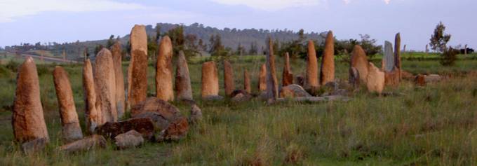
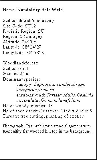
Kondaltity Bale Weld
Kondaltity Bale Weld has a limited area of high forest,
containing a group of black and white colobus monkeys, however there are large
areas of scrub in and around the church site that could be planted for both
timber production as well as increasing native tree cover.
 Bale Weld church and its surrounding forest are situated on top of a
high point or hill that punctuates a ridge which runs approximately North
South. The church and forest are approximately 100 m above the valleys to
either side. The church land occupies about 11 ha of which around 2 ha is
comprised of the relict forest. The remaining church land mostly on the hilltop
is almost completely proscribed by a short, steep, rocky, escarpment, and is a
fairly long, flat plateau mostly given over to secondary scrub dominated by Dodonaea angustifolia and Carissa edulis with some mature Juniperus procera. The escarpment, also
owned by the church, has a few remaining Junipers and some mature Podocarpus falcatus and eucalypts. The
surrounding slopes (probably once dominated by wild olive and juniper) are
owned by the Mikaeli-Semero Peasants association and grazing and cutting access
is currently unrestricted, there are a few mature junipers remaining in the
least accessible areas. There is a degraded plantation of eucalypts and Cupressus lusitanica on the southern
slopes, and low down on the south-eastern slope is another church site -
Chibchiba holy water (ca 1 ha), which is characterised by a variety of mature
and elegant native trees and recently planted exotic Schinus molle. Native vegetation in the surrounding landscape,
which is intensively farmed and highly gullied and degraded, is limited to
older gullies and sacred sites of the indigenous Gurage religion.
Bale Weld church and its surrounding forest are situated on top of a
high point or hill that punctuates a ridge which runs approximately North
South. The church and forest are approximately 100 m above the valleys to
either side. The church land occupies about 11 ha of which around 2 ha is
comprised of the relict forest. The remaining church land mostly on the hilltop
is almost completely proscribed by a short, steep, rocky, escarpment, and is a
fairly long, flat plateau mostly given over to secondary scrub dominated by Dodonaea angustifolia and Carissa edulis with some mature Juniperus procera. The escarpment, also
owned by the church, has a few remaining Junipers and some mature Podocarpus falcatus and eucalypts. The
surrounding slopes (probably once dominated by wild olive and juniper) are
owned by the Mikaeli-Semero Peasants association and grazing and cutting access
is currently unrestricted, there are a few mature junipers remaining in the
least accessible areas. There is a degraded plantation of eucalypts and Cupressus lusitanica on the southern
slopes, and low down on the south-eastern slope is another church site -
Chibchiba holy water (ca 1 ha), which is characterised by a variety of mature
and elegant native trees and recently planted exotic Schinus molle. Native vegetation in the surrounding landscape,
which is intensively farmed and highly gullied and degraded, is limited to
older gullies and sacred sites of the indigenous Gurage religion.
History
Aerial photography shows that
most of the deforestation of the surrounding slopes occurred before the early
1970s, that the boundaries of the relict forest have remained constant since
this time, and that much of the secondary scrub on the plateau and surrounding
slopes has grown up during this period. The plantation on the southern slopes
occurred during the Derg and a guard was present at this time to protect the PA
and the church land. Open access to PA land for grazing and cutting and church
land for grazing is a more recent state of affairs and there is evidence of
recent cutting of junipers. There are a number of mature eucalypts directly
surrounding the church some of which are interspersed in the relict forest; it
is unclear how the probable change of status of the church to monastery will
affect land use.
Threats
The declining economic status
of the church means that holy land and its biodiversity, especially Juniper,
has by necessity increasingly been viewed as an exploitable resource by its
guardians, and there is considerable interest in planting of economically
superior exotic species such as eucalypts and cypress both adjacent to and
within the relict forest. Recent availability of potentially invasive
agroforestry exotics may disrupt or threaten remaining indigenous biodiversity
in the long term.
The fashion for constructed graves threatens to
encroach upon the relict forest. Open access for grazing on church land, and
cutting and grazing on surrounding land threatens the whole hill with erosion.
The Chibchiba holy water site is currently under extreme threat from a deep
gully.
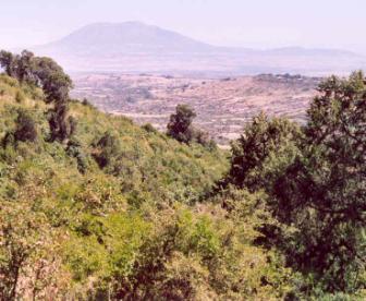
Much of the eastern slopes of Kondaltity Hill consists in
secondary scrub with a few forest trees (mainly Juniperus procera). Mt Ziqualla looms in the background.
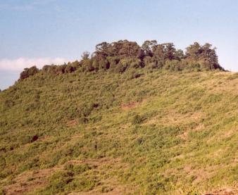
The flat summit of the hill is clearly evident from this
view taken from the North. The taller trees are eucalypts and the native forest
occupies much of the right of the hill top.
Conservation
status
The relict forest supports a group of Black and
White Colobus monkeys, which are popular amongst the local community. The
beauty of the biodiversity of the forest and its sacred status are held in very
high regard by the community.
Management
The size of the church site means that there
is considerable scope for planting of the desired economically superior exotic
species away from the relict forest and focus the planting on non-invasive
species. Whilst it is currently unclear as to what land use changes may be
entailed through the proposed status change to monastery, there is clearly
scope for long-term economic and conservation planning. PA and government
officials, NGO staff and many community members were interested in curtailing
unrestricted access to the surrounding slopes where regeneration and/or ecologically
informed planting may occur. Many of the above stakeholders felt that the
re-institution of a guard for both church and PA land would be of great
benefit. Gully prevention measures and resolution of conflicting use (sacred
and non sacred) of the holy water site is urgently required.